Aqua Vitae at the Free Dock in Portsmouth

Image

Aqua Vitae at the Free Dock in Portsmouth

Aqua Vitae at the Free Dock in Portsmouth

My frustration with WordPress continues. . . nowhere does it say “Save,” so if you click out of a screen too early it’s just simply gone! Also, it seems to me that the placement of the photos should be more manageable. I’d love to make it EASIER for the viewer. . . and DEFINITELY for me!

Being in Portsmouth is truly being in the south. . . take a look at this monument:To Our Confederate Dead

We didn’t leave Portsmouth yesterday until around 2 pm, as we were waiting for FedEx to arrive at the Mile Marker 0 Marine Store — a wonderfully cooperative owner, Bob, will help with just about anything I think!

South of Portsmouth on the Elizabeth River is mile after mile of huge structures, not pretty, but interesting, and several bridges that are too low for us to go under unless they are raised. It slows the trip, but we’re okay with that. There is also one lock, at Great Bridge, which raised us one foot to meet the water level of the remainder of the Virginia Cut.

Leaving PortsmouthLift Bridge Elizabeth River Continue reading

Solomons to Portsmouth

Yesterday our trip from Solomons to Windmill Point Marina was absolutely stunning, one of those magical bright days with water like silk that can happen occasionally on the Bay. There were fewer and fewer boats as we headed south, and the water got “bigger,” a few determined fishermen, and the crabbers are still out there as well.

Image

Our overnight stop was Windmill Point Marina, a lovely new facility which has very helpful staff, and very low water. . . WOW! We saw less than a foot under the keel (which is 4.5 feet down) as we came into the channel. The dockmaster says the tide has been really REALLY low in the last few weeks. A beautiful day, lovely sunset. . . Easy, smooth going — I’ll take more just like that!

Image

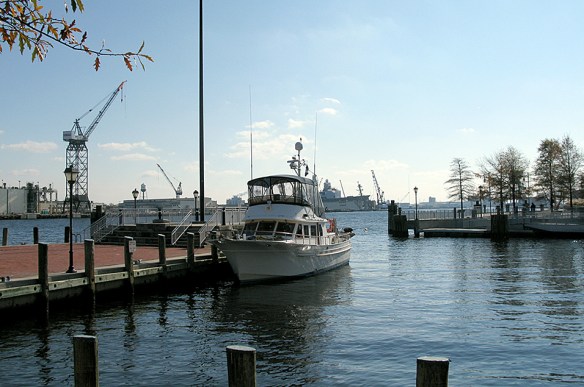
Today we left the dock just after 6:30, with plans to “beat the weather” to Portsmouth, which we did. . . we are at the free dock which is at the bottom of High Street, the center of most of the activity in this wonderful old city.

It was interesting to hear the chatter on the radio from several warships, one of which was warning all marine traffic to stay 15 miles away because of their “Live Fire Exercise.” Okay. . .  I’m not certain exactly where they were because the lat/lon they gave was always garbled. I do wonder if they have any idea how difficult it is to understand them when they get into their “official speak” mode. Norfolk is very definitely a city of ships, under construction, under orders (or not) or being “moth-balled.”

Image

Our trip today was 50 miles, and we were against the tide the entire way, so we averaged only 7.3 knots, which is about 9 miles an hour, slower than we usually go, but remember: this is not about speed, because that’s not something you can do in a trawler! We’ve come about 170 miles in total so far, and I am relieved to be at the bottom of the Bay. The Chesapeake can be challenging, and while I know there will be many challenges ahead, this was one that I feared. Whew!

With us at the free dock are two sailboats, one from Sweden (Think of THAT challenge!) and the other from Canada. The Canadians are ultimately headed for Guatemala, but will stop in the Bahamas and Cuba. Lucky!

**************************

So as a P.S., here is a view of the Christmas Tree at the end of High Street, right here at the free dock. No, it’s not snowing, it’s raining, but I just thought it was a lovely image. We are also joined by a dock walker who has seen better evenings. . . he seems fascinated by our boat, which I’m sure is just one of many that holds who-knows-what-kind-of possibilities for him. Ah well, we’re in the city.

Surprise at night in Portsmouth

On our way

On our way

This link is our Spot location. That’s a little gadget that sends signals to satellites to keep you informed of where we are. . . Save it in your favorites and you can watch as we head south.

Patapsco River Power Plant

Patapsco River Power Plant

We left the dock at 8:35 this morning. Leaving Baltimore is good, because it’s all about new beginnings and LOW ADVENTURE, right?

I’m posting some Baltimore/Patapsco River shots here. . . the Power Plant, Sparrows Point (the steel plant that was bought by the Russians but is no longer being operated at all — the picture was taken when it was still producing steel) and the Sandy Point Light, which is in the Bay, near the Bay Bridge. Again, this was taken in easier times, hence the fisherman standing in warm sun. . . which it is NOT today!

Sparrows Point Steel Plant, when it was still in operation


Sandy Point Light

This first day has been a bit rougher than we like, starting as beam seas, then pretty much on the nose, anywhere from 1 to 3 footers. Salt spray on the windows makes visibility difficult, especially when driving into the sun. Naja does not like it when we “bang” into a wave. She’s our little tornado dog (we think that’s why she was given up) and she has anxious moments when there are loud noises, or when the “house” shakes. I’m guessing it’s going to take her a few days to get to the point where it’s just part of her life.

Outside temperature is 37 degrees, but we’re cozy inside, as we’re running the generator for heat. I plan to add photos of the boat in the “About” section of the blog so you can see how we’re living.

I won’t be posting here every day, but if you’d like to get an e-mail when there’s a new post, click on “follow” in the sidebar.

Moving Aboard

Packed to the max. . . or is it?So. . . I’m guessing that ONLY a “fulltime cruiser” will understand how very small a 43 foot boat really is.

We have a V-Berth (at the bow, which is the pointy end of the boat), designed to accommodate guests in two ever-narrowing berths that end up with our guests very definitely playing footsie. We have a forward head (“bathroom,” in non-boating language) which has only a toilet and sink, for the comfort of our guests, because we prefer that our guests enjoy the tub/shower in the master stateroom (TRUE LUXURY!)

So the V-Berth is stacked high with. . . Carlsberg Beer, Diet Coke, Dog Food/treats, several (!!!) big bottles of Appleton Estate Rum,  and bedding for prospective guests (if they can find it. . . ). The Forward Head (remember, this is the guest toilet and sink) has Stoli Vodka (several big bottles), more Appleton Estate Run,  several half gallon bottles of some kind of toilet cleaner (tell me, is this reassuring??)

We’ve spent hours trying to tie down, or hide, or find space for. . . anything that can become a missile, or slide and fall, or break itself or something else as it gets rocked or rolled. TOMORROW, Sunday, we head out. The weather forecast is not ideal.  This is the beginning of our Adventure. (I remind you all that it’s supposed to be “LOW ADVENTURE!”)

Our first post. . .

Yes, we are actually going to DO IT! We’re going to put aside our obligations, duties, jobs, chores and HoneyDos. We’re going to move aboard Aqua Vitae, and Go.

“JUST GO!” is advice we’ve heard over and over from our boating friends who have done exactly that, and we (I, really, Peggy) have finally come to my senses. Not everyone has the opportunity to live their dream.

We will leave Baltimore and head south when we see a good weather window. A good weather window doesn’t mean balmy sunshine and sparkling waves, it means flat water. The Chesapeake Bay is a large body of water that can be very unforgiving, especially as air and water temperatures drop.

Our ultimate goal is to move slowly south, enjoying the people and places we meet. We will stop and smell as many “roses” as we can find, which may mean a lovely anchorage, or a charming town, both of which abound on the ICW (IntraCoastal Waterway) the “road” we will be traveling.